Posts
GPS တြင္ ေျမပုံအတြက္ setting ထည့္ျခင္း
- Get link
- X
- Other Apps

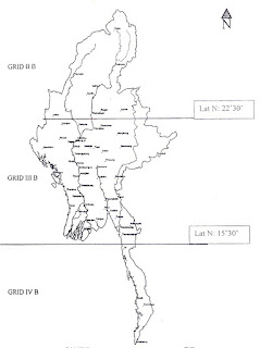
GPS တြင္ ေျမပုံအတြက္ Setting ထည့္ျခင္း ကၽြန္ေတာ္တို႔ ျမန္မာႏုိင္ငံမွာ အဓိက ေျမပုံအမ်ဳိးအစားႏွစ္ခုရွိတယ္ေပါ့ဗ်ာ။ ပထမတစ္မ်ဳိးက One Inch (၀ါ) Lambert လို႔ေခၚတဲ့ တစ္လက္မတစ္မိုင္စေကး ေျမပုံအမ်ုိးအစားနဲ႔ ေနာက္တစ္မ်ဳိးက UTM ေျမပုံအမ်ဳိးအစားေတြျဖစ္ပါတယ္။ ဒီပို႔စ္မွာေတာ့ ေျမပုံနဲ႔ တြဲသုံးတဲ့အခါ GPS မွာ Setting ေတြ ဘယ္လိုထားမလဲဆုိတာပဲအဓိက ေျပာၾကတာေပါ့ဗ်ာ။ ၁။ One Inch (or) Lambert အတြက္ ျမန္မာႏိုင္ငံကို ေအာက္ပုံမွာျပထားတဲ့အတိုင္း ဇုံသုံးခုခြဲထားပါတယ္။ ျမန္မာႏိုင္ငံအေပၚပိုင္းက IIB၊ အလယ္ပိုင္းက IIIB နဲ႔ ေအာက္ပိုင္းကို IVB အဲ့လိုခြဲထားတယ္ဗ်။ ပုံမွာျပထားတဲ့အတုိင္း မုံရြာၿမိဳ႕ရဲ႕အထက္ဘက္ 22°30' ရဲ႕အေပၚဘက္ဟာ IIB ။ 22°30' နဲ႔ 15°30' ရဲ႕ၾကားဟာ IIIB ။ 15°30' မိနစ္ရဲ႕ေအာက္ ေရးၿမိဳ႕ရဲ႕ ေအာက္ဘက္ျခမ္းေရာင္သြားရင္ IVB လို႔သတ္မွတ္ပါတယ္။ ဆိုေတာ့ GPS ကိုအသုံးျပဳမယ့္သူဟာ ဘယ္ေနရာမွာသုံးမွာလဲဆိုတဲ့အေပၚမူတည္ၿပီး One inch အတြက္ Grid Zone ကိုေရြးခ်ယ္ေပးဖို႔လိုပါတယ္။ ေနာက္ ၉၆° လိုင္းရဲ႕ အေရွ႕ဘက္ျခမ္းဆိုရင္ India Thailand Datum နဲ႔ အေနာက္ဘက္ကို India Bangladesh Datum...
Autodesk Software for Students, educators and educational instituions
- Get link
- X
- Other Apps

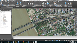
Pages - 8 File Size - 1 MB Geospatial data မ်ားကို ကိုင္တြယ္ရာတြင္ ေခတ္မီွ open source softwareမ်ား၊ Commercial softwareမ်ား ေျမာက္ျမားစြာရွိပါသည္။ open source software မ်ားကို သုံးစြဲရန္ လြယ္ကူလွေသာ္လည္း commercial software မ်ားကို သုံးစြဲရန္အတြက္မူ students/ educators/ education institutions မ်ားအေနျဖင့္ ဝယ္ယူသုံးစြဲရန္ ခက္ခဲလွပါသည္။ ၎တို႔အထဲတြင္ Auto CAD/ Auto CAD Civil 3D software မ်ားသည္လည္း အသုံးျပဳရလြယ္ကူသကဲ့သို႔ Geologistမ်ား၊ Mining Engineer မ်ား၊ GIS Technicianမ်ား အေနျဖင့္ ယေန႔အခ်ိန္အထိ လက္မလြတ္တန္း ကိုင္တြယ္အသုံးျပဳလ်က္ရွိပါသည္။ ယခုအခါတြင္ Autodesk Software Company အေနျဖင့္ students/ educators/ education institutions ကို ရည္ရြယ္၍ Free download students version မ်ားကို သုံးႏွစ္အထိ install လုပ္ကာ အသုံးျပဳခြင့္ေပးထားပါသည္။ Software install လုပ္ပုံအဆင့္ဆင့္ကို ေအာက္ပါ link တြင္ ေလ့လာနိုင္ ပါသည္။ Downlink - Mediafire
MapSource 6.15.7
- Get link
- X
- Other Apps

MapSource 6.15.7 MapSource 6.15.7 File Size (107) MB Coordinate မ်ားကို UTM, Lambert, Lat/Lon မ်ားေျပာင္းျခင္း Garmin GPS ထဲမွ Data မ်ားကို ကြန္ျပဴတာထဲသို႔ received ျပဳလုပ္ျခင္း ကြန္ျပဴတာထဲမွ Data မ်ားကို GPS သို႔ send ျပဳလုပ္ျခင္းစတာေတြကို ျပဳလုပ္ႏုိင္ပါတယ္။ Install ျပဳလုပ္ရန္ ၁. rar ဖိုင္ကို extract အရင္လုပ္ပါ။ ၂. Folder ထဲမွာပါတဲ့ exe ဖိုင္ကိုအရင္ install လုပ္ပါ။ ၃. Folder အျပင္က exe ဖိုင္ကို install လုပ္ပါ။ ေအာက္ကလင့္မွာ ေဒါင္းႏုိင္ပါတယ္။ download link Special Thanks - Khin Zaw Hein