Posts

GPS တြင္ ေျမပုံအတြက္ setting ထည့္ျခင္း

Image
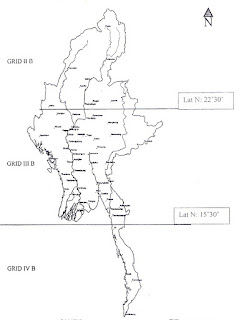
GPS တြင္ ေျမပုံအတြက္ Setting ထည့္ျခင္း ကၽြန္ေတာ္တို႔  ျမန္မာႏုိင္ငံမွာ အဓိက ေျမပုံအမ်ဳိးအစားႏွစ္ခုရွိတယ္ေပါ့ဗ်ာ။ ပထမတစ္မ်ဳိးက One Inch (၀ါ) Lambert လို႔ေခၚတဲ့ တစ္လက္မတစ္မိုင္စေကး ေျမပုံအမ်ုိးအစားနဲ႔ ေနာက္တစ္မ်ဳိးက UTM ေျမပုံအမ်ဳိးအစားေတြျဖစ္ပါတယ္။ ဒီပို႔စ္မွာေတာ့ ေျမပုံနဲ႔ တြဲသုံးတဲ့အခါ GPS မွာ Setting ေတြ ဘယ္လိုထားမလဲဆုိတာပဲအဓိက ေျပာၾကတာေပါ့ဗ်ာ။ ၁။ One Inch (or) Lambert အတြက္ ျမန္မာႏိုင္ငံကို ေအာက္ပုံမွာျပထားတဲ့အတိုင္း ဇုံသုံးခုခြဲထားပါတယ္။ ျမန္မာႏိုင္ငံအေပၚပိုင္းက IIB၊ အလယ္ပိုင္းက IIIB နဲ႔ ေအာက္ပိုင္းကို IVB အဲ့လိုခြဲထားတယ္ဗ်။  ပုံမွာျပထားတဲ့အတုိင္း မုံရြာၿမိဳ႕ရဲ႕အထက္ဘက္ 22°30' ရဲ႕အေပၚဘက္ဟာ IIB ။ 22°30' နဲ႔ 15°30' ရဲ႕ၾကားဟာ IIIB ။ 15°30' မိနစ္ရဲ႕ေအာက္ ေရးၿမိဳ႕ရဲ႕ ေအာက္ဘက္ျခမ္းေရာင္သြားရင္ IVB လို႔သတ္မွတ္ပါတယ္။ ဆိုေတာ့ GPS ကိုအသုံးျပဳမယ့္သူဟာ ဘယ္ေနရာမွာသုံးမွာလဲဆိုတဲ့အေပၚမူတည္ၿပီး One inch အတြက္ Grid Zone ကိုေရြးခ်ယ္ေပးဖို႔လိုပါတယ္။ ေနာက္ ၉၆° လိုင္းရဲ႕ အေရွ႕ဘက္ျခမ္းဆိုရင္ India Thailand Datum နဲ႔ အေနာက္ဘက္ကို India Bangladesh Datum...

Autodesk Software for Students, educators and educational instituions

Image
Pages - 8 File Size - 1 MB   Geospatial data မ်ားကို ကိုင္တြယ္ရာတြင္ ေခတ္မီွ open source softwareမ်ား၊ Commercial softwareမ်ား ေျမာက္ျမားစြာရွိပါသည္။   open source software မ်ားကို သုံးစြဲရန္ လြယ္ကူလွေသာ္လည္း commercial software မ်ားကို သုံးစြဲရန္အတြက္မူ students/ educators/ education institutions မ်ားအေနျဖင့္ ဝယ္ယူသုံးစြဲရန္ ခက္ခဲလွပါသည္။ ၎တို႔အထဲတြင္ Auto CAD/ Auto CAD Civil 3D software မ်ားသည္လည္း အသုံးျပဳရလြယ္ကူသကဲ့သို႔ Geologistမ်ား၊ Mining Engineer မ်ား၊ GIS Technicianမ်ား အေနျဖင့္ ယေန႔အခ်ိန္အထိ လက္မလြတ္တန္း ကိုင္တြယ္အသုံးျပဳလ်က္ရွိပါသည္။ ယခုအခါတြင္ Autodesk Software Company အေနျဖင့္ students/ educators/ education institutions ကို ရည္ရြယ္၍ Free download students version မ်ားကို သုံးႏွစ္အထိ install လုပ္ကာ အသုံးျပဳခြင့္ေပးထားပါသည္။ Software install လုပ္ပုံအဆင့္ဆင့္ကို ေအာက္ပါ link တြင္ ေလ့လာနိုင္ ပါသည္။   Downlink - Mediafire

MapSource 6.15.7

Image
MapSource 6.15.7 MapSource 6.15.7 File Size (107) MB Coordinate မ်ားကို UTM, Lambert, Lat/Lon မ်ားေျပာင္းျခင္း Garmin GPS ထဲမွ Data မ်ားကို ကြန္ျပဴတာထဲသို႔ received ျပဳလုပ္ျခင္း ကြန္ျပဴတာထဲမွ Data မ်ားကို GPS သို႔ send ျပဳလုပ္ျခင္းစတာေတြကို ျပဳလုပ္ႏုိင္ပါတယ္။ Install ျပဳလုပ္ရန္ ၁. rar ဖိုင္ကို extract အရင္လုပ္ပါ။ ၂. Folder ထဲမွာပါတဲ့ exe ဖိုင္ကိုအရင္ install လုပ္ပါ။ ၃. Folder အျပင္က exe ဖိုင္ကို install လုပ္ပါ။ ေအာက္ကလင့္မွာ ေဒါင္းႏုိင္ပါတယ္။ download link   Special Thanks - Khin Zaw Hein

Total Station

Image
Total Station အေျခခံသေဘာတရားမ်ား Total page (26) File size (380) KB download link   Special Thanks - Ko Khin Zaw Hein

Soil Types Of Myanmar

Image
DownLink _ Mediafire_ Soil Map DownLink _ Mediafire_Soil_Info Wai Toee 23 November at 01:46 Edited... Grids, shapefile and Soil info are available now 😁 ျမန္မာႏိုင္ငံရဲ႕ Soil Types Map ပါ ကိုယ္သံုးဖို႔လုပ္ရင္း လိုအပ္တဲ့သူမ်ားသံုးႏိုင္ေအာင္ မ်ွေဝလိုက္ပါသည္ Original source ကေတာ့ Food and Agriculture Organization (FAO) ကပါ ျမန္မာႏိုင္ငံအတြက္ေတာ႔ အဆင္သင့္စားဖို႔ရန္ ဇြန္းတပ္ေပးထားပါတယ္ 😜 Soil type နာမည္တူေနတာကေတာ့ Dominant Soil ကိုပဲ ယူထားလို႔ပါ General name တူေပမယ့္ Composition ကြဲပါတယ္ Thanks to Original Uploader  - https://www.facebook.com/wai.toed.1/posts/1139808182851958

LAMBERT PROJECTION ႏွင့္ UTM (Universla Transverse Mercator)

Image
LAMBERT PROJECTION ႏွင့္ UTM (Universla Transverse Mercator) LAMBERT PROJECTION (Lambert Conical Orthomorphic) ႏွင့္ UTM (Universla Transverse Mercator) ေျမပုံအရိပ္ခ်ျခင္းဆိုင္ရာစာတမ္း Total page (55) File size (9.26) MB download link Special Thanks http://dagongeology.blogspot.com Khin Zaw Hein

တုိင္းႏွင့္ ျပည္နယ္ေျမပုံမ်ား

Image
Ka Chin (10.6) MB Download Link Ka Yar  (11.34) MB Download Link Chin (10.93) MB Download Link Shan (10.56) MB Download Link Sa Gaing (10.46) MB Download Link Ma Gway (10.4) MB Download Link Ka Yin (9.73) MB Download Link Man Da Lay (9.28) MB Download Link Yan Gon (8.97) MB Download Link Ba Go (7.76) MB Download Link Ra Khine (7.7) MB Download Link Aye Yar Waddy (7.03) MB Download Link Tanintharyi (6.78) MB Download Link Mon (28.06) MB  Download Link Android ဖုန္းမွာ install လုပ္လို႔ရတဲ့ ဒဂုံဘူမိ Apk ဖိုင္ကို ဒီလင့္ ကေနတစ္ဆင့္ ၀င္ေရာက္ေဒါင္းယူႏုိင္ပါတယ္။ Thanks Ko Khin Zaw Hein

Landslides and GIS

Image
Landslides and GIS DownLink - Mediafire

ASSESSMENT OF URBAN DEVELOPMENT PATTERN AND URBAN PLANNING BY USING LANDSAT DATA

Image
ASSESSMENT OF URBAN DEVELOPMENT PATTERN AND URBAN PLANNING BY USING LANDSAT DATA Prof. Dr. Htun Ko Head of Geography Department University of Yangon Presentation Down Link _ mediafire

Drought Assessment for Agriculture in Shwebo Town By Using Landsat Data

Image
Down Link _ Mediafire တုိးတက္ေနေသာ နည္းပညာေခတ္တြင္ Remote Sensing Technologies ကိုလည္း ယေန႕ေခတ္တြင္ တြင္တြင္က်ယ္က်ယ္ အသုံးျပဳလာေနၾကၿပီး ျဖစ္သည္။ ထုိ႕အျပင္ စုိက္ပ်ဳိးေရးတြင္လည္း အသုံးျပဳအေကာင္ထည္ေဖာ္ ေဆာင္ရြက္ထားၿပီး ျဖစ္ပါသည္။ ျမန္မာႏုိင္ငံသည္လည္း စုိက္ပ်ဳိးေရးျဖင့္ အဓိကအားထား လုပ္ကုိင္ေနရေသာ ႏုိင္ငံျဖစ္သည္အမွ် အပူပုိင္းေဒသ မွုံရြာေဒသတြင္ Landsat Satellite Data ျဖစ္ေသာ Thermal Infrared Bands (eg. Band 10 and 11 in Landsat 8 ) ကုိ အသုံးျပဳၿပီး Surface Temperature မွ Drought Assessment ကုိ ေလ့လာသုံးသပ္သြားမည္ ျဖစ္သည္။ သုိ႕ေသာ္လည္း ထုိသုိ႕ ဘာေၾကာင့္ တြက္ခ်က္ရသည္ ဘယ္လုိနည္းလမ္းမွန္မွန္ကန္ကန္ျဖင့္ (Proper Methodology and Assessment) ေဆာင္ရြက္ရမည္ကုိ Integrated Learning Approach နည္းျဖင့္ ေဆြးေႏြးတင္ျပသြားသည့္ Paper Presentation File ျဖစ္ပါသည္ Speaker – Professor Dr. Htun Ko

GEOCHEMICAL ANOMALY AND MINERAL PROSPECTIVITY MAPPING IN GIS

Image
GEOCHEMICAL ANOMALY AND MINERAL PROSPECTIVITY MAPPING IN GIS   GEOCHEMICAL ANOMALY AND  MINERAL PROSPECTIVITY MAPPING IN GIS EMMANUEL JOHN m. CARRANZA Total page (347) File size (13.74) MB download link Android ဖုန္းမွာ install လုပ္လို႔ရတဲ့ ဒဂုံဘူမိ Apk ဖိုင္ကို ဒီလင့္ ကေနတစ္ဆင့္ ၀င္ေရာက္ေဒါင္းယူႏုိင္ပါတယ္။

Surfer 8Program Manual

Image
Surfer 8Program Manual     Surfer 8 Program Manual  (Myanmar Version) Total page (24) File size (3.55) MB By Myo Aung & Soe Lwin Oo Asia World Company Limited Nam Paung Coal Project Download Link ကြန္ျပဴတာနဲ႔ေဒါင္းသူမ်ား ေဒါင္းရခက္ရင္  ဒီပို႔စ္  ကိုဖတ္ပါ။ ပို႔စ္အသစ္တင္တိုင္း မိမိဖုန္းမွာၾကည့္ႏုိင္တဲ့ Androidသုံး dagongeology.apk ဖုိင္ကို  ဒီပို႔စ္  မွာ၀င္ေရာက္ေဒါင္းယူႏိုင္ပါတယ္။

QGIS လက္ေတြ႕ေလ့က်င့္ခန္းစာအုပ္

Image
QGIS လက္ေတြ႕ေလ့က်င့္ခန္းစာအုပ္ အေျခခံ GIS သင္တန္း QGIS လက္ေတြ႕ေလ့က်င့္ခန္းစာအုပ္ Myanmar Information Management Unit Total page (184) File size (8.62) MB Download link Android ဖုန္းမွာ install လုပ္လို႔ရတဲ့ ဒဂုံဘူမိ Apk ဖိုင္ကို ဒီလင့္ ကေနတစ္ဆင့္ ၀င္ေရာက္ေဒါင္းယူႏုိင္ပါတယ္။ MMIU ဆိုဒ္မွ ျပန္လည္ ကူူးယူျဖန္႔ေ၀ပါသည္။

CONTROLS ON GOLD-COPPER MINERALIZATION AT PATUN AREA, BANMAUK TONWHSIP, SAGAING REGION

Image
CONTROLS ON GOLD-COPPER MINERALIZATION AT PATUN AREA, BANMAUK TONWHSIP, SAGAING REGION CONTROLS ON GOLD-COPPER MINERALIZATION AT PATUN AREA, BANMAUK TONWHSIP, SAGAING REGION By Zaw Lin Aung Total page (108) File size (5.52) MB download link Android ဖုန္းမွာ install လုပ္လို႔ရတဲ့ ဒဂုံဘူမိ Apk ဖိုင္ကို ဒီလင့္ ကေနတစ္ဆင့္ ၀င္ေရာက္ေဒါင္းယူႏုိင္ပါတယ္။ ေဒါင္းရခက္ရင္ ဒီပို႔စ္ ကိုဖတ္ပါ Special Thanks - Khin Zaw Hein

State & Region Distance Map

Image
State & Region Distance Map တိုင္းေဒသႀကီးလမ္းမိုင္ အကြာအေ၀းျပ ေျမပုံမ်ား ေဒါင္းလင့္မွေဒါင္းပါ Download Link Download Link Download Link Download Link Download Link Download Link Download Link Download Link Download Link Download Link Download Link Download Link Download Link Download Link Download Link Download Link Download Link Android ဖုန္းမွာ install လုပ္လို႔ရတဲ့ ဒဂုံဘူမိ Apk ဖိုင္ကို ဒီလင့္ ကေနတစ္ဆင့္ ၀င္ေရာက္ေဒါင္းယူႏုိင္ပါတယ္။   Special Thanks - Khin Zaw Hein

Rockwork 14 Program Manual (Myanmar Version)

Image
  Rockwork 14 Program Manual (Myanmar Version) By U Myo Aung & U Soe Lwin Oo Asia world Company Limited Total page (34) File size (35.6) MB Android ဖုန္းမွာ install လုပ္လို႔ရတဲ့ ဒဂုံဘူမိ Apk ဖိုင္ကို ဒီလင့္ ကေနတစ္ဆင့္ ၀င္ေရာက္ေဒါင္းယူႏုိင္ပါတယ္။  Down Link - Mediafire Special Thanks - Khin Zaw Hein

UAV Technologies In Myanmar

Image
UAV Technologies in Myanmar File size 1.43 MB Pages - 15 DownLink - Mediaf DownLink - Mediafire ire

UTM Maps of Myanmar

Image
UTM Maps of Myanmar ျမန္မာတစ္ႏုိင္ငံလုံး UTM ေျမပုံမ်ားကုိ Mosaic လုပ္ထားတာျဖစ္ပါတယ္။ ဖုိင္ဆုိဒ္ 10 GB ဆုိေတာ့ေတာ္ေတာ္ေလးမ်ားတယ္ဆုိေတာ့ ကြန္ပ်ဴတာနဲ႕ wifi နဲ႕ေဒါင္းမွ အဆင္ေျပမယ္ထင္ပါတယ္။ special thanks - Khin Zaw Hein DownLink - Mediafire

84 E 14 15 16 F 9 10 13 14 15 I 2 3 4 J 1 2 3 ဖလမ္း၊ကေလးၿမိဳ႕ဧရိယာ၊ခ်င္းေတာင္ေျမာက္ပိုင္း

Image
 84 E 14 15 16 F 9 10 13 14 15 I 2 3 4 J 1 2 3 ဖလမ္း၊ကေလးၿမိဳ႕ဧရိယာ၊ခ်င္းေတာင္ေျမာက္ပိုင္း File Sizes - 49.17MB DownLink - Mediafire

Remote Sensing and Geoscience

Image
Remote Sensing and Geo-science File size 4.66MB Pages - 108 DownLink - Mediafire